


CHAPELLE STE MARGUERITE

Benteux
User
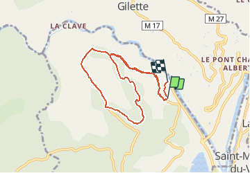

Length
8.4 km

Max alt
390 m

Uphill gradient
286 m
Km-Effort
12.4 km

Min alt
124 m

Downhill gradient
321 m
Boucle
No
Creation date :
2021-03-21 10:08:06.635
Updated on :
2021-03-21 10:08:52.845
2h48
Difficulty : Easy

FREE GPS app for hiking
 SityTrail
IGN / Geographical institutes
SityTrail Plus
The world is yours!
About
Trail Walking of 8.4 km to be discovered at Provence-Alpes-Côte d'Azur, Maritime Alps, Le Broc. This trail is proposed by Benteux.
Description
MARCHE
Positioning
Country:
France
Region :
Provence-Alpes-Côte d'Azur
Department/Province :
Maritime Alps
Municipality :
Le Broc
Location:
Unknown
Start:(Dec)
Start:(UTM)
353062 ; 4854990 (32T) N.
Comments